We're Back in Touring Mode Again
Friday 10th and Saturday 11th March 2017
Hooray, Hooray, Hooray, we're back on the road again😁. We'd quite enjoyed our time at The Golden Coast Holiday Village near Woolacombe, but maybe a whole month was a bit too much - it's the longest we've stayed in one place anywhere during our last 18 months of living in our motorhome.

So we'd both got very itchy 👣 but that didn't mean we were going to travel far - in fact our target was Westwood Ho which was only about 20 miles away, but 😞 when we got there our 7.5 metre motorhome was too big to fit in any of the overnight parking spaces they provide. Never mind, as usual we'd got a plan B - we just had to nip back down the road to Appledore where there is another mixed parking area that welcomes motorhomes for the nocturnal period, and as an added bonus we're just metres from the water's edge - and all for just 8 quid!

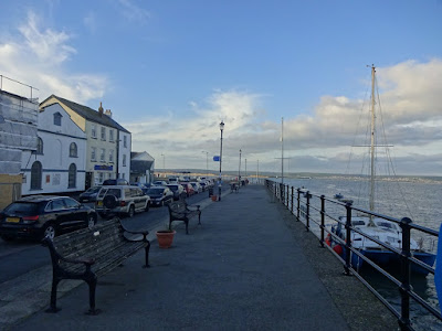
The pictures to the left and below show The Old and The New Appledore, and in the early 1800's Salmon fishing was big business, but in those times the water side houses all had individual jetties at the end of their gardens and it wasn't until 1840 that it was turned into one long quay side where people still stroll to enjoy the sea air today.

When we arrived the sun had very firmly got it's hat on, so it didn't take us very long to scoff our pizza and then get off out to play.
So Friday's jaunt was a little 8 mile stroll (there and back) into Westwood Ho, but to get there we first had to traverse through Appledore's quaint cottage lined ancient lanes where the brightly coloured dwellings all had names related to the ocean.
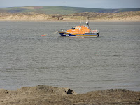
And a little further on we passed by the RNLI Lifeboat station and learnt that in one form or another they had been officially saving lives in this area since 1825.
At this point we needed to make a choice either to continue to follow the coastal path, or to divert onto a quiet lane, but as I hadn't really got sensible 👠 on, and as the path was very muddy we chose the later.
 |
| Grandad's Shed! |
And then it didn't take us much longer before we found ourselves in Westwood Ho where there was a huge number of pretty little beach huts on one side of the promenade, and a fantastic seascape on the other! At high tide the water comes right up to the sea wall, but at low tide miles of sand is uncovered and there are also loads of rock pools to explore. We sat and watched the waves for a while, and then decided it was time to go home cos we could just as easily watch them from T4rdis2's windows with a cuppa in our hand😁
On Saturday we decided a more strenuous walk was on our agenda, and although this required us to cover some of the same ground as yesterday, it eventually took us out over a spit of land called Northam Burrows Country Park.

Once there we followed the Coastal Path around the boarder of the Park and were rewarded with stunning views across the salt march back towards Appledore in one direction, and as we rounded the headland we could see Westwood Ho in the distance. Additionally, early in our walk, we also had lovely views over the moorland in the middle where ponies roamed, and then later the vista changed to rolling golf links.

Eventually we also came to the strange phenomenon of The Pebble Ridge which extends along the coastline of Northam Burrows for 2 miles. Initially we thought it was a man made sea defence because the 'pebbles' are stacked up very neatly in a long high mound, but apparently it has been formed naturally by a process called ' long shore drift ', and the Taw/Torridge estuary is one of the few places that this occurs. Nearly all of the 'pebbles' in the 'wall' were worn smooth by the action by the action of the sea, but some of them were huge and 'boulders' may have been a better description for them.
The trail ultimately took us back into Westwood Ho, but that provided an excellent spot for our lunch, and after we'd dawdled there for a while all we had to do was retrace our steps to take in the opposite views from the Burrows to get home - but this provided all new vistas because by now the tide was rushing in.
Sunday 12th March 2017

Today was a moving day - a 60ish mile move into Cornwall that was made via Lidl at Wadebridge for re-stocking, and then on to Rick Stein's territory at Padstow, and here we'd treated ourselves to a very posh campsite just above the village. We arrived in the early afternoon, so after a quick lunch we set off across their recommended footpath to Padstow - and at the start of our walk we were nice and clean! However, by the time we'd literally '
slipped and slid' through all the
s..t puddles and mud that we found along the way, we looked far from presentable by the time we got there - we wont be going that way again! But it didn't really matter because we'd no plans to go anywhere 'posh', we just wanted to do a little nosing around the cobbled higgledy piggledy streets that are home to all manner of unique shops and eateries, and to see the old fishing harbour that is still in full working order today.
Padstow is housed in one of 49 coves around Cornwall that shelter fishing boats of all sizes, and from what we saw fishing was very firmly woven into the fabric and heritage of the area. Within the harbour there were numerous working boats, and additionally, there were quite a few places were you could buy the fruits of their labours.
Monday 13th March 2017.
Now, while we're in this area we've decided we might try to do 'The Padstow 100' - 😁 not a well known challenge, just one John and I have made up! We plan to either 🏃or 🚴 100 miles in the 4 days we're here. Only trouble is, we only clocked up about 5 miles yesterday, so we're going to have our work cut out to complete it!

With that in mind we cycled the full length of The Camel trail today - twice - (there and back)😁, but it has to be said, the first part of the trail where it tracks the estuary from Padstow to Wadebridge is the best bit. The trail follows the route of the old Bodmin and Wadebridge Railway which was first established in 1834, and was apparently one of the oldest in the country.
As the route moves away form the estuary it enters old woodland and it is here that it passes by The Camel Valley Vineyard, which was planted in 1989 and now has 24,000 vines that produce award winning 🍷, but unfortunately it was closed today so we couldn't sample their wares😒. From there on we traversed deeper into the woods, and although there was plenty to see in the way of wild flowers and bird life, it did eventually become a bit monotonous. And then we started to notice a bit of dampness in the air, which elicited John's comment that
'the weather was turning PLUVIAL'! maybe from now on we'll have to have a 'special word' for each day!!
Anyway, after about 2 hours we rolled into Wenfordbridge - a tiny little hamlet in the middle of nowhere, and a place whose one shining glory is a cafe and bike hire shop called The Snail's Pace Cafe, but it's a good job we weren't relying on it for our lunch cos that was closed as well - so out came our trusty picnic which we sat and ate at one of their tables.


Our total mileage for the day was 40, so to meet our goal we're definitely going to have to keep up the good work tomorrow!
Tuesday 14th March 2017
Our target millage for today was another 40, so with that in mind we set off following Sustran's route 32 towards Newquay - and it was a good job we'd got fully charged batteries! Gentle hills started almost from the beginning, but they came with John's warning off
'don't waste your battery cos you'll need it later' and he certainly knew what he was talking about!!
Our ride was nearly all on quiet lanes, and to start with these traversed through farmland where high hedge rows obscured our views, but that only lasted as far as our lunch stop at the settlement of Porth. From there on the vistas were stunning - grey gunmetal sea, low moody misty skies, craggy cliffs and Big
Big Hills!! It was fantastic, and even when we were huffing and puffing up the steepest ones we were still well and truly distracted by the panoramas that disclosed themselves as the road twisted and turned following the rugged coast line.
We passed by Watergate Bay and through the hamlets of Tregurrian, Mawgan Porth, Porthcothan, and then we came to the very lovely Treyarnon and Constantine Bays. After that we detoured a little to Trevose Head - a place we'd visited before when we did our long tour of Cornwall with our friends Sharon and Paul.


However today there wasn't anybody riding their bikes out over the headland!! We had our final break there, and then turned our wheels homeward, and even though our ride had been an exhausting exhilarating one, we'd still fallen well short of our goal and only done 36 miles - if we're going to meet our target it's going to be a very long walk tomorrow!
Wednesday 15th March 2017
And it was!! We left T4rdis2 around 10.30 and headed down to Padstow before joining the coastal path to the left of the village and heading for Gunver Head.

But, we hadn't gone far before we were stopping to gaze over the notorious 'Doom Bar' - a huge sandbank which extends from Hawkers Cove to within about 200 metres of the Greenway Rocks - and a phenomenon which causes a major hazard to shipping entering the estuary. In the period between 1800 and the early 1900s records show that over 200 ships came to grief in this area, and this eventually resulted in the advent of a Coast Guard Lookout at Stepper which lies just above the Doom Bar.
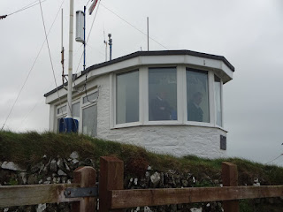
Sadly, in 1994 due to financial constraints and an improvement in communication systems the Watch House was closed and abandoned, and then through disuse it became derelict. However in April 2000 it was given a new lease of life when volunteers renovated it and manned it once again, and since then it has been instrumental in initiating several rescue operations that have saved lives.
From there our walk took us further out along the jagged cliffs until we came to a disused chimney/tower that John tried to hide in! Can you spot
Wally him in the pics below😂.


And from there it didn't take us much longer to reach Gunver Head where we stopped for lunch while overlooking the noisy crashing waves below, and while we were noshing on our sarnies we decided we'd had enough exercise for one day and that we should should start wending our way back home. So we about turned and retraced most of our steps back the way we had come, however at one point we did scramble down onto the fantastic massive beach that would eventually be completely covered by the incoming tide.

Our walk had been challenging but stunning, and we both agreed that it was a bit of a shame that it had to be finished off by the trek up the road from Padstow back to our campsite. But in the end it was a bit of a giggle as we passed by a field where we met these 2 chaps. Initially John started to make donkey noises to communicate with them - but then he decided he was talking out of his ass!
We think the mileage for today was about 14, making a total of 95 miles over the last 4 days - Bugger - we didn't quite achieve our goal - we'll have to try harder next time
See you soon 😗😗
Click here to see our UK parking spots
And just before I go we'd like to wish Val John and Mum a 'happy moving in day' for tomorrow - try not to work too hard xxx
 Thursday was moving day so we left our lovely little camping spot at Greenwoods in the New Forest and headed to Herston Yard Farm Campsite near Swanage on the Jurassic Coast - and it's ok here but I much prefer the small cosy sites really! Our journey wasn't far, but as we'd stopped a couple of times - once at a farm shop and again at Lidl to restock our goodies cupboard, we arrived around 2ish, and then our afternoon walk into town was further delayed because I took the time to make some delicious broccoli and stilton soup for our late lunch - yummy!


 We settled down on a big rock that doubled as a bench and got our sarnies out, and from our comfy perch we could literally watch the sea dance! Apparently, Dancing Ledge is so called because at certain stages of the tide when the waves wash over the horizontal surface of rock that sits just below the ledge the water undulates and bobs about as if dancing. However, in times gone by this part of the coast has performed a much more functional purpose because the ledge forms a straight drop off into the sea which is deep enough for small ships to come right up to it. Therefore, in the 18th and 19th centuries stone was ferried from here and taken around the south coast of Kent to Ramsgate where it was used to build the Harbour there.

 On Saturday we decided we'd give our walking muscles a rest and cycle instead - just a little 38 mile round trip to Lulworth Cove and back - and by the time we got there we were very glad of our battery propelled bikes cos there were more than one or two hills! However, although our ride was quite lovely in parts, it didn't turn out to be one of the best because when we arrived in the very pretty town of Lulworth it was almost impossible to move because of the crowds - well it was Saturday and the sun had well and truly got it's hat on! And unfortunately, the crowds weren't the only thing that caused a bit of disgruntlement to our day - there were 2 others occasions - when John managed to acquire punctures - first in his front wheel and then in his back!

 On Sunday it was back to walking again and today our target was Old Harry's Rocks, on a circular route that would be about 12 miles. We left T4rdis2 and headed for the little settlement of Ulwell from where we needed to climb about 200 steps up to an obelisk that is situated on the Coastal Path on Ballard Down. Apparently it was rescued from London by George Burt and was erected in it's present spot in 1892 to mark the completion of a nearby resevoir. However, during WWII it was dismantled because it was thought to be an aid to enemy aircraft, but then later re-erected as a memorial by the Voluntary Men of 129 Field Squadron Royal Engineers.


